|
Vermessung der Welt mit Satellitenfotos
|
Vermessung der Welt mit Satellitenfotos
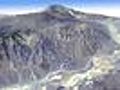
Die Nasa hat in Zusammenarbeit mit dem japanischen Wirtschaftsministerium die größte und genaueste topografische Karte der Erde veröffentlicht. Aus insgesamt 1,3 Millionen Satellitenfotos erstellten Wissenschaftler ein dreidimensionales Erdmodell. Dieses steht nun Wissenschaftlern, Studenten und Städteplanern kostenlos zur Verfügung.
Video Length: 69
Date Found: July 02, 2009
Date Produced:
View Count: 0
|
|
|
|
|
I got punched by an old guy, for farting near his wife. Read MoreComic book creator Stan Lee talks the future of the medium in the digital age. Panelists Zachary... Read MoreThe U.S. launch of Spotify is still on music lovers' minds. Join Zachary Levi, from NBC’s... Read MoreTuesday: Rupert Murdoch testifies before Parliament on the hacking scandal that brought down "News... Read MoreAfter a long slump, the home construction industry may be showing signs of life. But as Bill... Read More | 1 2 3 4 5 |
|
|
|