|
Holocaust Museum’s Crisis in Darfur on Google Earth
|
Holocaust Museum’s Crisis in Darfur on Google Earth
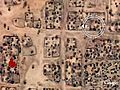
The Museums Mapping Initiatives use tools such as Google Earth and animated maps to enable citizens to understand Holocaust history and bear witness to current threats of genocide across the globe. Crisis in Darfur displays the destruction in Darfur, Sudan through photographs, articles, and testimonies via Google Earth. This information appears as a Global Awareness layer in Google Earth. On July 30, the Museum updated Crisis in Darfur with the latest US Department of State data that sheds new light on the extend of the genocide in Darfur. The new data shows that more than 3300 villages have been damaged or destroyed, primarily between 2003-2005, in the Darfur region of Sudan. This is more than twice the number that was identified in previous US government assessments and strengthens the evidence of a vast, targeted campaign of destruction against civilians. To find Crisis in Darfur on Google Earth, visit www.ushmm.org Information on the Museum’s Genocide Prevention Mapping Initiative and the Holocaust mapping layer can be accessed from the Museum's Web site at www.ushmm.org
Video Length: 188
Date Found: March 31, 2011
Date Produced: March 31, 2011
View Count: 1
|
|
|
|
|
I got punched by an old guy, for farting near his wife. Read MoreComic book creator Stan Lee talks the future of the medium in the digital age. Panelists Zachary... Read MoreThe U.S. launch of Spotify is still on music lovers' minds. Join Zachary Levi, from NBC’s... Read MoreTuesday: Rupert Murdoch testifies before Parliament on the hacking scandal that brought down "News... Read MoreAfter a long slump, the home construction industry may be showing signs of life. But as Bill... Read More | 1 2 3 4 5 |
|
|
|